


Kentucky’s first potential significant winter storm of the season will affect primarily the southern and southeastern parts of the state this weekend.
Joe Sullivan with the National Weather Service office in Louisville said the system will enter the state near Hopkinsville on Saturday night.
“The bulk of the precipitation will be falling between midnight and noon on Sunday,” he said. “We’re forecasting 1-2 inches of snow and sleet south of the Cumberland Parkway.”

This system will be a quick-hitter, he said. “Sunday afternoon and evening, the whole system will move off to the east, exiting eastern Kentucky Sunday night.”
He predicts dry conditions on Monday.
Sullivan said areas north of the Western Kentucky and Bluegrass Parkways with conditions east of Lexington, north of I-64, mostly dry. Just south of that an inch or less of snow and sleet is forecast, but south of a line from Bowling Green to London to Pikeville, 1-2 inches are likely.
The highest accumulation will be in the counties that border Virginia, according to Sullivan. “Black Mountain might get five-and-a-half inches out of this, the rest between two and four inches.”
Sullivan says the mix of precipitation is not going to include a lot of freezing rain. “It’s going to be more sleet and wet snow than anything, which will keep the numbers down.”
“Some of the computer models keep it completely out of Kentucky and keep it in the Volunteer State, so this is a worst-case scenario-type forecast.”
Sullivan added: “For those of you who had been hoping for a big winter snowstorm out of this, well, you could always go to Asheville, North Carolina, because they’re going to get dumped on.” Forecasters are predicting over a foot of snow there.
Once this system is through, a slow warming trend is expected, with highs in many parts of Kentucky reaching 50 or more by Thursday.
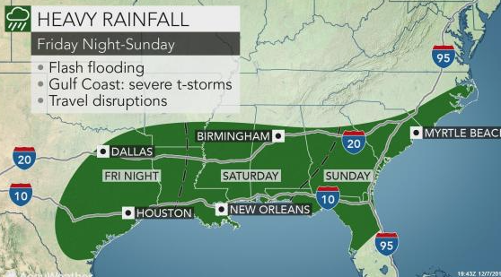
Areas from northwestern Texas to northern Arkansas got ice and snow from the storm and disruptions due to rain and flooding are likely along the Interstate 10 and I-20 corridors.
Very heavy rainfall and flooding will be a big threat with this storm, according to AccuWeather Meteorologist Ryan Adamson.
Most areas from the lower Mississippi Valley to the southern Atlantic Seaboard received above-normal precipitation during the month of November, leaving the ground saturated and making it harder for additional rainfall to soak in.
Soaking rain will first gather over central, southern and eastern Texas and spread into southern Arkansas and northern Louisiana on Friday and Friday night.
“Cities that may experience enough rain for travel difficulties and flash flooding include Dallas, Houston, Austin and San Antonio, Texas; Little Rock, Texarkana and Pine Bluff, Arkansas; and Shreveport, Louisiana,” said AccuWeather Senior Meteorologist Alex Sosnowski.
While greatest risk to lives and property will be from flooding, feisty thunderstorms are possible.
Drenching rain and locally severe storms plowed eastward over the weekend.
Downpours swept through much of Georgia, northern and central Florida and South Carolina from Saturday night to Sunday.
During the storm’s journey from Texas to the southern Atlantic Seaboard, rainfall amounts will range between 2-4 inches with an AccuWeather Local StormMax™ of 8 inches possible.
Coastal areas from Louisiana to the Florida Panhandle may experience such storms during the first half of the weekend, before the threat shifts into the Florida Peninsula on Sunday.
Damaging winds and flooding downpours will be the greatest threats along this swath, but isolated tornadoes cannot be ruled out.
While the southern tier deals with flooding and severe weather, wintry weather will not be too far away, with a major snow and ice event expected for North Carolina and southern Virginia.